
Kepulauan Seribu Regency

Kepulauan Seribu (English: Thousand Islands) is the name for chains of islands to the north of Jakarta's coast as well as the name of the onlyregency of Jakarta, Indonesia. It consists of a string of 110 islands stretching 45 kilometers north into the Java Sea.
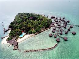
A decree states that 36 islands may be used for recreation. Of these 36 islands, only 13 islands are fully developed: 11 islands are homes to resorts island and two islands are historic parks. Twenty-three islands are privately owned and are not open tothe public. The rest of the islands are either uninhabited or support a fishing village.
| Kepulauan Seribu Thousand Islands | |
|---|---|
| — Regency — | |
 | |
| Coordinates: 5°36′S 106°33′E Coordinates: 5°36′S 106°33′E | |
| Country | |
| Province | Jakarta |
| Capital | Pramuka Island |
| Government | |
| • Bupati (Regent) | Drs. Burhanuddin, MM |
| Area | |
| • Total | 8.7 km2 (3.4 sq mi) |
| Population | |
| • Total | 21.071 |
| • Density | 2.4/km2 (6.3/sq mi) |
| Time zone | WIB (UTC+7) |

History
The modern history of the Kepulauan Seribu chain of islands begins with its role in the defenses of the city of Batavia for the VOC and the Dutch colonial empire. Since the establishment of Batavia in 1610, Onrust island has been a naval base.
After the VOC failed to obtain control on trade activities in Banten in 1610, the Dutch obtained permission from Prince Jayakarta to build a dock at one of the islands in Jakarta Bay as a place to repair and equip ships sailing to Asia, particularly South East Asia. The island Prince Jayakarta assigned to the VOC was Onrust Island, a 12 hectare island 14 km from Jakarta.

In 1615 the VOC built a shipyard and a small storage house on the island, which Jan Pieterszoon Coen hoped would eventually develop into a trade and defence base against threats from Banten and England (1618). The VOC constructed a small rectangular fort with two bastions in 1656; the bastions protruded from the fort and were used as look-out posts.The fort was enlarged in 1671 and given an asymetrical pentagonal shape with a bastion in each corner. The whole structure was made of red bricks and coral. In 1674 additional storage buildings were built.
.jpg)
In 1795, Dutch position in Batavia became quite uncertain due to the war in Europe at the time and the situation became worse with the appearance in 1800 of a British naval squadron under the command of Captain Henry Lidgbird Ball of HMS Daedalus. Daedalus, HMS Sybille, HMS Centurion and HMS Braave entered the area, which they referred to as Batavia Roads. They seized five Dutch armed vessels and destroyed 22 other vessels. Onrust island was under siege by the British and eventually destroyed.
After the British departed, the Dutch rebuilt the buildings and facilities, completing the work in 1806. However, a second British attack, led by Admiral Edward Pellew, again destroyed the fort. When the British occupied Batavia in 1810, the buildings in Onrust island were repaired until the British left Indonesia in 1816.
Onrust island was again given attention in 1827 during the period of Governor General G.A.Baron Van Der Capellenand activities in the island were normal again in 1848. In 1856 a floating shipyard was built for repair works at sea. However, the construction of Tanjung Priok harbour in 1883 resulted in a decline in the role and significance of Onrust island.

In 1911-1933, Onrust island was the quarantine place for Hajj pilgrims. A barrack was built in 1911 to contains 35 units for about 100 pilgrims.. From 1933 until 1940, Onrust island was the detention place for mutineers involved in the Incident of the Seven Ships (Zeven Provincien). In 1940 it became the detention place for Germans, such as Steinfurt who was the Chief Administrator of Onrust Island. After the Japanese entered Indonesia (1942), the role of Onrust island declined again and it became the detention place for serious / grave criminals.
After Indonesia proclaimed her independence, the island became the quarantine place for lepers, under the control of the Indonesia Ministry of Health, until 1960. The lepers hospital was then moved to Post VII at Tanjung Priok harbour. After a coup by General Suharto, Chris Soumokil, who declared the self-proclaimed Republic of South Moluccas and placed himself as a president, was arrested and later executed by order of President Suharto in Onrust Island on April 21, 1966.
In 1972 Ali Sadikin, then governor of Jakarta, declared Onrust Island a protected historical site. In 2002 the administration made Onrust and its three neighbors - the island of Cipir, Kelor and Bidadari - an archaeological park to protect the artifacts and ruins on the islands that date back to the time of theDutch East India Company.
Ecology
An area of 107,489 hectares of land and sea was declared by the Minister of Agriculture in 1982 and designated by a Forestry Ministrial Decree in 2002 as the Taman Nasional Laut Kepulauan Seribu (Thousand Islands Marine National Park). Public access is prohibited on two of the islands, Panjaliran Barat and Panjaliran Timur, where sea turtles are conserved.
The Kepulauan Seribu Marine National Park is located 45 km north of Jakarta. It is mostly located on the Kecamatan of Kepulauan Seribu Utara (the northern part of Kepulauan Seribu island chain). The complex contains 342 reef platforms, with 110 formes an island larger than half an acre. There may be as many as 700 individual reefs in the complex.
In general, the plants that grow in the Park are dominated by coastal species like coconut palm (Cocos nucifera), pandan (Pandanus sp.), cemara laut (Casuarina equisetifolia), cangkudu (Morinda citrifolia), butun (Barringtonia asiatica), mangroves (Bruguiera sp.), breadfruit (Artocarpus altilis), ketapang (Terminalia catappa), and kecundang (Cerbera odollam).
Sea vegetation commonly found in the Park consists of seaweed divisions like Rhodophyta, Chlorophyta and Phaeophyta as well as classes of sea grasses like Halimeda sp., Padina sp., Thalassia sp., Sargassum sp., and Caulerpa sp.
The dominant animals in the Park include 54 sea biota species which form part of the coral reef ecosystem, 144 species of fish, 2 species of giant clam, 6 species of sea grass, sea worms of various colours and 17 species of coastal bird.
This Park forms a hatching site for hawksbill sea turtle, and green sea turtle. The hawksbill turtle is an endangered species and is rarely found in other waters. These turtles are bred on Pramuka Island. This activity is aimed at recovering the turtle population, which had almost reached extinction. Breeding activities include egg hatching in a semi-natural way and caring for the baby turtles till they are ready to be released into their natural habitat.
Most coastal areas of this Park are surrounded by mangrove forest, where iguanas, golden ring snakes and reticulated pythons can be found.


0 komentar:
Post a Comment